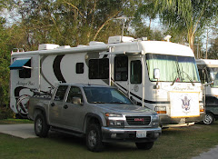
We previously visited Carlsbad, NM, & the world famous caverns located there a year ago last March. When we departed Carlsbad & drove to El Paso, TX, we were very impressed with the silhouette of El Capitan located on the southern edge of Guadalupe Mountains National Park, & placed the Park on our list of places to visit in the future. Unfortunately, the Park entrance is not “convenient” to any RV parks, & there are no stores or gas stations close to the Park. So this year we decided to stay in Carlsbad, NM, & “commute” in the Toad to Guadalupe Mountains National Park.
After setting up camp on upon our arrival Sunday, 27MAR, Dan decided to drive the Toad to Sitting Bull Falls in the Lincoln National Forest. The Falls are a day use facility of the National Forest that has many stone picnic shelters in a very scenic setting. No one knows why the falls are called Sitting Bull, but agree that they are not named after the famous Lakota Sioux Chief who never came close to New Mexico! This area of NM, & most of Arizona & Texas, has been enduring a major drought (some towns have had no measurable rain in more than 150 days); so we were afraid there would be no falls to view. But it turns out that the falls are fed by an underground spring that has never gone dry. After a short hike we came to the falls; although not a dramatic “high volume” flow of water, it was still very scenic & a refreshing break from the desert heat. 

Monday morning we headed to Guadalupe Mountains National Park, & it was a very windy drive. The Park has less than two miles of roads but has over 80 miles of trails. First thing we did was visit the Visitor Center to watch the slide show & find out if there were any Ranger led activities scheduled (there weren’t). Turns out the Guadalupe Mountains are a small part of a gigantic ancient reef that has only broken the earth’s crust in three locations – Guadalupe Mountains, Apache Mountains, & Glass Mountains. The Park has three distinct climates - Desert Zone, Riparian Zone & Mountain Zone. Unfortunately to see the truly spectacular sites of the Park, usually means a very strenuous hike. For example, to view the alpine environments means a vertical climb of 2000 to 3000 feet!
After visiting the Visitor Center it was a short walk to The Pinery, the ruins of a Butterfield Overland Mail Station. The Overland Mail made two trips a week over a period of 2-1/2 years, carrying passengers, freight and up to 12,000 letters from St Louis, MO, to San Francisco, CA (& vice versus). The western fare one-way was $200, with most stagecoaches arriving at their final destination 22 days later. The Butterfield Overland Stage Company had more than 800 people in its employ, had 139 relay stations, 1800 head of stock and 250 Concord Stagecoaches in service at one time; before the Civil War stopped its operations. 

Trivia – what two present day major companies can be traced to the Butterfield Overland Stage (hints – one company still has a stagecoach on its corporate logo; & don’t leave home without the other one)?
From the Visitor Center it was short drive to the Frijole Ranch; a very well preserved ranch complex consisting of the main house, bunkhouse, spring house, stables, & one room schoolhouse. From the ranch we hiked the Smith Spring Trail, this a 2-1/2 mile loop, rated as “moderate”. Being out of shape, coupled with the rocky terrain & high winds; we rate it as “strenuous”! Once you leave the ranch there are no trail markers to indicate if you are still on the right trail or how far to go. Every now & then Corrie would ask if Dan was sure we were on the right trail? Eventually we made it to Smith Spring, another underground source of water in the Chihuahuan Desert. After returning to the Toad we decided we were so tired, that we would skip the supposedly easier & more scenic McKittrick Canyon Trial. We will just have to make another trip to the region in the future?

Trivia – the Frijole Ranch had a “gas generator” for lighting; since this was before Edison invented the light bulb, how did it work?


No comments:
Post a Comment