granddaughter coraline

granddaughter coraline

grandson mason

grandson mason

grandson jaxson

grandson jaxson

Sunday, September 30, 2012

26-28SEP12 - Capitol Reef National Park, UT (3rd stop on the grand circle tour)

Wednesday, 26SEP, we hit the road for Capitol Reef National Park (largest monocline in North America), UT. We took scenic byway state road SR 12 the first national scenic byway in Utah thru the Grand Staircase-Escalante National Monument; supposedly the most scenic road in the USA. We haven’t driven them all yet, but it is number one to us at this point. Starting with the hoodoos of Bryce Canyon, SR 12 has examples of all the “rock” formations of the Colorado Plateau including sliprock benches & canyons, uplifts, to cinder cones. The last part of SR12 was not completed until 1985, & is a narrow ridge road with drop offs on both sides & no shoulders. On the way, we stopped at the Escalante Interagency Visitor Center, which has info from the BLM, Forest Service & local State Parks. We also stopped at the Homestead Overlook at about 9600 ft elevation to view the beautiful aspen trees in full fall color.

After making it to Torrey, UT, we set up camp, ate lunch, & headed to Capitol Reef National Park’s Visitor Center for requisite video & info. Where we discovered the surrounding 200 acres around the Visitor Center was known as Fruita, & up ten Mormon families planted & harvested fruit & nut trees for close to a century. Eventually the remoteness & constant threat of flash floods discouraged most families & they left. Even though the remaining orchards are not “natural” to the environment, the Park Service maintains them as they are of historical value. In fact for a nominal fee you can harvest whatever is in season, so we picked some apples. Finally we headed to Loa, UT, for groceries & to visit the National Forest office.

Thursday morning it was back to the park for a full day of exploring. First stops were to view Native American petroglyphs & Fruita School, a one room school house use until 1941. Then we visited the Gifford Homestead where generations of Giffords lived until they sold out to the Park Service in 1969. The original house has been restored & contains period furniture along with displays of life at Fruita. In addition there is a small store in the house that sales “period” items handcrafted by Mormons today based on authentic details, along with bakery items centered on the fruits & nuts grown at Fruita.

Then we commenced driving the park’s dead end scenic drive; first we drove to the very end so we could then take a dirt road into Capitol Gorge. When we came to the end of the dirt road, we hiked for about an hour further into the gorge where we saw more petroglyphs & a portion of the gorge wall where early day pioneers carved their names into the rock. We finished the day by backtracking to the RV, stopping at all the scenic overlooks we had passed-by on the way in, & doing a few more short hikes.

http://www.nps.gov/care/index.htm

Friday was an all day offroad drive on the Burr Trail, followed by Hells Backbone before completing the circle back in Torrey. We started the drive on the east side of the National Park by driving almost due south on Notom/Bullfrog Rd thru BLM land. This road is in the bottom of what is called the Waterpocket Fold, this is North America’s largest monocline & is the geographic event that created Capitol Reef. Views of the Fold in the park don’t do it justice because you only see small portions of it. The Fold runs basically north to south for over a hundred miles & you can only see long stretches of it from the Notom/Bullfrog Rd or from an airplane. Then we headed west on the Burr Trail (amazingly this was a cattle trail created by Mr Burr!) where we re-entered the National Park & soon encounter the infamous Burr Switchbacks. As we continued westward we left the Park for the Grand Staircase-Escalante National Monument (the first national monument under BLM management). Supposedly the Grand Staircase-Escalante area was the last place in continental USA to be mapped. After 86 miles & two hours we arrived in Boulder on SR 12 for a brown bag lunch break.

http://www.blm.gov/ut/st/en/fo/grand_staircase-escalante.html

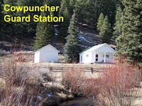
After recovering from the first part of the drive, we then headed to the Hells Backbone Rd (aka the Poison Rd – one drop & your dead) in the Dixie National Forest. This road was built by the CCC in 1933 to shorten the distance between Boulder & Escalante, UT. We stopped at the one lane bridge at Death Hollow for photos. We also discovered a small house called the “Guard Station at Cowpuncher”. Guard stations were set up by the Forest Station to be one day’s horse ride apart for their Rangers. With the improvement in their dirt roads & 4-wheel drive, they are no longer needed; but now they are being preserved & are available for rent. Usually they don’t have electricity, but thanks to propane they do have hot water & indoor cooking equipment. At the end of our drive we even encountered modern day cowboys moving cattle down the road.

After resting a little back at the RV, we headed into Torrey for a walkabout (all 3 stores); & great hamburgers at Slackers, top 10 rated in Utah (Dan had to try fried green beans & pumpkin shake, both very good).

http://www.fs.usda.gov/main/dixie/home

Capitol Reef National Park is another jewel in the National Park Service system; but to really to understand the Waterpocket Fold & get “good” view of it, we recommend taking the time to drive the Notom/Bullfrog Rd.  Unfortunately, there were no Ranger led activities that we have come to expect at every National Park.

Thursday, September 27, 2012

23-25SEP12 - Bryce Canyon National Park, UT (2nd stop on grand circle tour)

23SEP, Sunday, we drove to Panguitch, UT; set up camp & head to Bryce Canyon National Park Visitor Center to watch their video & get info (note - Bryce is not a canyon in spite of the name); we also signed up for tomorrow’s 9AM free bus tour. We then visited the Bryce Canyon Lodge & cabins designed by Gilbert Stanley Underwood as part of the Union Pacific RR Grand Circle. Note – the “original” Grand Circle is different than what we discussed in our last BLOG. The original one was sponsored by Union Pacific RR & included the north rim of Grand Canyon NP, Kanab NF, Pipe Spring NM, Zion NP, Cedar Breaks NM, & Bryce Canyon NP. Underwood designed four lodges for the Union Pacific – Grand Canyon, Zion, Cedar Breaks & Bryce. One has been destroyed, the ones at Grand Canyon & Zion have been significantly changed (ie modernized), & only Bryce’s is still original.


Then it was quick view of rim, before heading back to the RV with a few short stops, the first was at Ruby’s Inn (aka Reuben Syrett) just outside the Park. Ruby’s was originally in the Park on a verbal agreement & was called Tourist’s Rest, until “kicked out” by the Union Pacific RR & the building of their Lodge. So they are now just outside the Park gate, & they have the only traffic light in Garfield County.
http://www.rubysinn.com/

Ruby’s was followed by a visit to the Forest Service’s Red Canyon Visitor Center of the Dixie National Forest for more free info about the surrounding area. That evening it was back to National Park for the 4:30PM Ranger led Rim Walk & talk. As part of the Ranger’s presentation he insisted that everyone get real close to a ponderosa pine & smell the bark; you should try it the next time in the forest.

Early Monday morning it was back into the park for early twice daily bus tour. These free bus tours are different from the one we took in Zion, in that the there is no Ranger onboard & the bus driver gives the running commentary. Turns out the bus driver was very informative & funny, & a Ranger was not needed. The bus tour starts loading outside park near motels, we were going to board inside the park; but at last minute we decided to board at Ruby’s & lucked out; because their big bus broke & the replacement bus was smaller & several people could not board.

First the bus tour drives to the end of the dead end scenic park road for your first stop. Then the bus retraces the route stopping at about half the scenic overlooks, while the bus driver gives a running commentary. At the overlooks the driver points out many things not obvious to everyday park visitors. At the end of over three hours the driver took us to an observation point that many people don’t even realize is part of park – Fairyland Point (in fact you can go to this point without entering park & paying $25).

After the bus tour we headed back to the historic Bryce Canyon Lodge for lunch. While at the lodge we signed up for a two hour horseback tour tomorrow (not free). Then we drove all the way back up the dead end scenic park road so Dan could see a Bristlecone Pine, which required a short hike. These Bristlecones are only 1600 years old & are not very dramatic as the ones we have seen in pictures. So seeing a “real” Bristlecone is still on our to do list. Then it was back to the RV to rest a little before heading into the town of Panguitch for a walkabout.
Trivia – who were Robert LeRoy Parker & Harry Alonzo Longabaugh (think Newman & Redford)? What is the difference between a bridge & an arch rock formation?

Even though we had had rain all night & were concerned that the steep, narrow trail might be slippery; we still got up early to head back to park for our horseback tour of Bryce Canyon. Even though we were definitely sore at the end of the two hours, it was a fantastic time & definitely worth the money! Then it was off to the Park’s General Store for some snacks. For our last hours in the park we visited the view points of Paria View, Bryce Point (the very best in the entire park), & Inspiration Point.

Trivia – what is known as the cowboy Cadillac? Why are mules more sure footed than horses (hint – has do with eye sight)?

After returning to RV for some recuperation, Dan & Gumbo took off for some four wheeling on forest service roads. First stop was the Casto Canyon Trail in the Red Canyon to do a little hiking. After a few minutes into the trail Dan realized it was a designated ATV trail, & decided to try another trail before getting run over. Eventually they safely rejoined Corrie back at the RV.

We thought Zion National Park was extremely dramatic & scenic, but Bryce Canyon National Park is now number one in our opinion!

Monday, September 24, 2012

20-22SEP12 - Zion National Park, UT (start of the grand circle tour)

Thursday, 20SEP, we drove from Baker, NV, to Virgin, UT, to visit Zion National Park. This will be our first stop on what is called the Grand Circle of National Parks (Zion, Bryce Canyon, Capitol Reef, Arches, & Canyonlands) in Utah. Upon arrival at the RV park we set up camp & headed to the Zion Visitor Center to sign up for tomorrow’s “9AM Ride with a Ranger” bus tour, & view the Center exhibits. Then we drove to the Zion Human History Museum to view a short documentary about the park & view more exhibits, before heading back to the RV.

www.grandcircle.org

Friday morning we were up bright & early to insure we did not miss our Ride with a Ranger. In our opinion this is a must do! First of all no private cars are allowed on the dead end scenic canyon road from May to November. A propane powered bus system has been in place since about 2000. Usually we are not a fan of these “forced” public transport systems; but we can see how a park that gets three million visitors a year had to take drastic actions. The end result is no more gridlock when 65,000 people try to visit the park on long weekends, & a 75% reduction in air pollution! Anyway, one bus a day has park ranger onboard giving a very informative & interesting talk; & the bus gets to stop at pullouts that the other busses don’t stop at.


After riding with the ranger we then hiked the Weeping Rock Trail & the Lower Emerald Pool Trail. After a brown bag lunch on the lawn of the Zion Lodge, Corrie headed back to RV for R&R, while Dan hiked the Riverside Walk Trail which leads to the Narrows Trail thru a slot canyon; he hiked a little of the Narrows before heading back to the Visitor Center to meet up with Corrie. Note – when you hike the Narrows trail, over half the time you will be wading in the Virgin River which created Zion Canyon. It seemed to Dan that half the tourists hadn’t read the park brochures & were taken by surprise having to get wet? Also, our informal survey shows Dutch to be the second most common language in the park, after English!

Early Saturday morning, 22SEP, we jumped in the Toad for an auto tour of the “rest” of Zion National Park, Cedar Breaks National Monument, & Kolob Canyons. First we had to drive back into Zion National Park so we could drive state road 9 thru the Zion-Mount Carmel highway tunnel. Since the tunnel was finished in 1930 (at the time the longest tunnel in the USA), it is not large enough for today’s RVs, trailers, campers, or even boat trailers. So during the day they only allow alternating oneway traffic, & large vehicles drive down the center of the tunnel. The tunnel takes you to the east side of Zion park where the rock formations have a different visual appearance & the vegetation is some what different than that found in Zion Canyon itself.

http://www.nps.gov/zion/index.htm

Once we left the east side of Zion Park, we continued in counterclockwise direction on state roads to Cedar Breaks National Monument. This is a natural scenic wonder that is overshadowed by Zion National Park & therefore receives few visitors.
We continued on our circular route to our last stop, the finger canyons of the Kolob Canyons portion of Zion National Park. The Kolob Canyons are in the NW corner of Zion but cannot be reached from within Zion itself. To reach the Kolob Canyons you must get on I-15 & take the appropriate exit. Again this scenic wonder is overshadowed by the rest of Zion, & receives few visitors.

http://www.nps.gov/cebr/index.htm

We can not even begin to describe the beauty & awesome vistas of Zion National Park or Cedar Breaks National Monument, so we won’t even try to in this BLOG. Even the hundred or so pictures we took don’t do them justice. All we will say is don’t add it to your so called bucket list, just do it & get here soon!

Saturday, September 22, 2012

17-19SEP12 - Great Basin National Park, NV (via wells, nv)


Monday, 17SEP, we drove to Wells, NV, to spend the night. We have expressed our opinion several times in this BLOG how the interstate highway system and the “national” store chains have destroyed small town America. There are no national store chains in Wells (except the dollar store) but you can clearly see how each improvement of the USA transportation system has slowly destroyed businesses in town. The first businesses were on Front St because it fronted the RR tracks and station. Then when US93 was created two blocks off Front St, the businesses on Sixth St flourished and the buildings on Front St are now fenced off, missing roofs and falling down. With the building of the Eisenhower Interstate System the only businesses still making money are located next to the I80 off-ramps and the buildings on Sixth St are boarded up. After dinner we head to the only casino left in business, The 4-Way Casino open since 1954, where we were given one free dollar. Dan doubled his money putting him $2 ahead, we won’t tell you how much Corrie set us back!
Tuesday morning started we the drive to Great Basin National Park near Baker, NV. Heading south on US93 we soon realize how remote travel in NV can be - 115 miles to next gas, no radio, no cell phone. We made it to Baker, NV, at lunch, set up camp, ate lunch and headed to the Great Basin National Park Visitor Center for the requisite watching of videos and procuring informational brochures. One thing we knew wanted to do, was go on the guided tour of Lehman Cave, but turns out you need to go to the Lehman Cave Visitor Center to sign up? We are not sure why this park needs two visitor centers, but off we went; signed up and paid for the 9AM tour tomorrow. Dan needed his shoes decontaminated because he had been in other caves with them in the last year; decon consisted of placing the soles of your shoes in 1/2 inch of disinfectant for five minutes.

Then we drove the Wheeler Peak Scenic Drive starting at 6500 ft and ascending to 10,000 ft. They say for every 1000 ft gain in elevation it is the same as driving north 600 miles. You start at a sagebrush steppe, then pinyon-juniper woodlands along aspen lined creek beds, thru shrubby mountain mahogany and manzanita, into deep forests of englemann spruce and douglas fir, ending the drive in subalpine forest and alpine meadows. The only park environment we did not experience was stands of bristlecone pines, which takes a four hour round trip hike at 10,000 feet to observe. Then it was back to town and to the only grocery store to get the last container of sour cream for stroganoff. Note – it appears that literally every business in town is for sale! Thankfully they remain open, but every business we visited (including the RV park) had a Realtor sign on it.  

Trivia – there are four deserts in North America (discussed a couple of times in this BLOG), which is the only “cold” desert?

After dinner Dan and Gumbo headed out for a walk-about & discovered several examples of “folk” art that always seem to occur in remote areas where people might have too much time on their hands?

Wednesday morning it was back to the Lehman Caves Visitor Center for the 9AM tour; in a word – fantastic!Dan wasn't prepared for the coolness of the caves and had to buy a sweater at the gift shop; the lady at the gift shop said they make a lot of money on sweatshirts even in the middle of the summer! Then we headed in the Toad to find Strawberry Creek campground road, so Dan can do a little offroad driving and then some easy hiking at the end of it. After two false starts we finally found it, only to discover that the road was closed after driving half of it! Dan then took Corrie back to the RV for R&R; stopping at the Fremont Native American archeological site on the way back. Dan then drove back into the park to hike part of the Osceola Ditch Trail. The Osceola Ditch was an 18 mile attempt by gold miners to bring water to the mine site by digging a ditch, tunneling, & building a flume; unfortunately it was completed just as a drought hit.     http://www.nps.gov/grba/index.htm

Dinner that night was at the Silver Jack Inn and LectroLux Café. Turns out the only employee to show up was the owner; the proverbially one armed paper hanger! Still a great meal, even if our choices were limited because of missing personnel. As we walked back to the RV we noticed several people dressed as pirates and wenches headed to the local bar. Turns out it is international “Talk Like a Pirate Day”, aka TLAP Day (arrr!). In fact, it is the tenth anniversary of this internet created “day” that was thought up by two guys in Oregon. It looked like to us that the entire town of Baker was in costume and celebrating?

http://www.silverjackinn.com/

http://www.talklikeapirate.com/piratehome.html