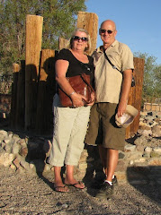
Friday, 22APR, we departed Phoenix for the finally leg of our drive to the Pacific NW. First stop was the Riverside Casino in Laughlin, NV. Read our below BLOG entry about how Don Laughlin turned an out of the way motel serving cheap chicken dinners into the second most visited city in Nevada.
http://theryanrvexpress.blogspot.com/2010/04/1415apr10-laughlin-nv-happy-tax-day.html
Saturday, we overnighted in Bakersfield, CA; & Easter Sunday we ended up at Happy Time RV in Dunnigan, CA. We are not sure how the permanent residents of the “park” were celebrating Easter, but we noticed they were setting up a rock & roll band outside & everyone was clearly drinking large quantities of their favorite adult beverage. Must be why they call it Happy Time RV? We noticed the gas station across the road had $3.99 gas & was mobbed all night long with customers coming off the I-5 interstate. Monday, 25APR, we overnighted in Redding, CA, at an RV park we seem to stay at every time we pass through on I-5 (see below BLOG link for more details on Redding).
http://theryanrvexpress.blogspot.com/2010/04/16-19apr10-various-ca-bend-or.html
26APR, Tuesday, we drove from Redding through two high mountain dry lake basins (aka Playas) to camp at Eagle’s Nest RV in Tionesta, CA. The object was to tour Lava Beds National Monument. Tionesta is near Tulelake, CA, & extremely remote. In spite of the remote location the owner of the RV park had a smart phone with an attachment to take credit cards, & when the transaction was done you signed your name on the smart phone using your finger as a pen & the receipt was emailed to you! Since there was some daytime left after setting up camp we took the Toad to explore the immediate area & Tulelake, a very small town (& we mean small).


 Wednesday we spent all day at Lava Beds National Monument; the National Monument contains the largest concentration of lava tubes in USA (over 500 with more than 20 open to public). But the National Monument is not just lava flows & tubes, it is also the main battlefield of the Modoc War, 1872-73, the only Indian War in California, & Petroglyph Point one of largest panels of Native American rock art in the USA.
First stop as always was the Visitor Center to get info on the park & view the dioramas & video(s). From there it was off to examine several of the “easier” lava tubes. By easier it means no steep sections to climb up or down, & no crawling on your belly. Some of the more difficult tubes have passages that are twelve inches high! We then continued on driving on the park “loop” road to view Mammoth Crater & Hidden Valley. Next stop was the fire lookout at Schonchin Butte. Upon our arrival at the trailhead of the fire lookout we discovered the trail was about .7 mile straight up! At that point Corrie decided to take a break, while Dan decided to go for it. After narrowly avoiding a heart attack on the hike up, Dan was rewarded with 150 mile views of California, Oregon & the Sierras.
We continued the drive through the National Monument stopping to view the Fleener Chimneys, Captain Jacks (real name Kientpoos) Stronghold, & Petroglyph Point. At the Stronghold we learned the history of the brief Modoc War. The interaction between the Modoc Indians of the Tulelake area & the ever increasing European immigrants followed the path of almost all Native American tribes: first mutual cooperation & trade with the Europeans; then resentment as the Europeans settled permanently & took “ownership” of all the lands that Native Americans believed no one owned; & then finally armed conflict.
The difference in this tale was that the Modocs were forced to sign a treaty that moved them north to share a Reservation with the Klamath Indians in Oregon. Unfortunately the Modocs being in the minority were treated poorly by the Klamaths & even the representatives of the USA gov’t. This led Chief Kientpoos to leave the Reservation with about 160 Modocs & seek a Reservation of their own in the area of their traditional lands around Tulelake. Although he & his followers did not attack the “Europeans”; the newly arrived Europeans felt threatened & demanded the Army force the Modocs back to the Oregon Reservation.
Eventually the Modocs took refuge in the lava beds & tubes, & waged a guerilla action against the Army, holding off a superior force that was twenty times their number. The Modocs’ actions were widely publicized in the press back East gaining a large, sympathetic, support of the public. Unfortunately one of Kientpoos’s followers killed the senior Army representative during negotiations & the public opinion then turned against the Modocs. The Modocs that followed Keintpoos were eventually defeated & were not even returned to the Oregon Reservation, but shipped to Oklahoma. To this day the few surviving Modocs in Oregon & Oklahoma refuse to even visit Tulelake.
Trivia – who is the only USA Army General to die fighting the Indians (it is probably not who you think)?


http://www.nps.gov/labe/index.htm
Unfortunately we did not have time to visit the Tule Lake Unit of the “WWII Valor in the Pacific National Monument” created in 2008, to serve as a reminder of the hardships endured on the home front during WWII. As such the new National Monument has three separate sites dedicated to the home front: Pearl Harbor for obvious reasons; Attu Island & Kiska Island in the Aleutians because they were the only USA land occupied by the Japanese; & Tulelake, CA. Why Tulelake? Because it was the site of one of the ten War Relocation Centers used to “house” Japanese Americans who were forcibly removed from “exclusion zones” on the west coast. The vast majority of these Japanese Americans (NOTE - if you were 1/16th Japanese, you were relocated!!!) were loyal to the USA but they endured the “home front” hardships of losing their freedom, their possessions & their businesses because of their race. Tulelake was selected out of the ten sites because - it was the largest; the only one to be redesignated as a Segregation Center (not a good thing); & the only one where martial law was declared (a really bad thing). Right now there is no funding & the few exhibits are in a temporary location with no full time staff. We hope to come back when the National Monument has permanent facilities, & spend some time learning more details about this sad chapter of USA history.
http://www.nps.gov/valr/index.htm
http://www.nps.gov/tule/index.htm
Thursday as we drove north to Bend, OR, we were treated to constant snow & sleet flurries; which made the drive more stressful than usual. After arrival at RV park Dan discovered that we were near the world famous Petersen Rock Gardens. So naturally we had to take off in the Toad (in the snow) to visit them. Born in Denmark, Rasmus Petersen (1883-1952) built his rock garden in the last 17 years of his life, in tribute to his adopted new country, the USA. He collected rocks, petrified wood, glass, and shells from around Redmond, OR, & began building replica structures at the age of 52. His creative Dementia Concretia eventually yielded a scaled-down Statue of Liberty, a U.S. Capitol building, & impressive Independence Hall.


That evening, or more correctly Friday early AM, Corrie got up to watch the royal wedding, while Dan stayed in bed & ignored the entire affair. By the time Dan did get up, it had started to snow again in Bend; which led to a debate about staying another day in Bend, or driving in the snow again? Thanks to the internet we could see the highway conditions further north were clear & dry. So the decision was to wait for the temperature to raise & then continue driving north. That afternoon we made it to the Yakima Indians’ Legends Casino in Toppenish, WA, without incident. Where Dan did very well, but Corrie lost more than her fair share!
Tomorrow, Saturday, back at cousin Steve’s & Bonnie’s in Kittitas, WA!